
Regulating Riparian Buffers
Vegetated stream buffers, or riparian buffers, are important to the health of streams and other water bodies they border. They provide shade to help moderate water temperature which helps maintain optimal dissolved oxygen levels; they provide filtration of and help slow stormwater flows and decrease runoff pollution; they help stabilize stream banks to reduce erosion and sedimentation; and they provide movement corridors, shelter, and feeding/watering habitat for wildlife. Moreover, most people agree that there is an aesthetic value that comes with having vegetation in a landscape.
When conducting a survey for water resources during the pre-construction phase of development, ecologists do not only think about what resources may be federally jurisdictional Waters of the U.S. (WOTUS), but they also consider which resources are also waters of the state subject to state and local riparian buffer requirements.
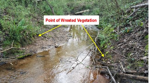
In Georgia, the Georgia Erosion and Sedimentation Control Rules, 391-3-7, promulgated under the Georgia Erosion and Sedimentation Act, O.C.G.A. 12-7, dictate that state waters having wrested vegetation by normal stream flow or wave action (for example, intermittent streams, perennial streams, ponds, lakes, reservoirs, etc.) are subject to either 25-foot vegetated buffer or 50-foot vegetated buffer requirements as measured horizontally from the point of wrested vegetation. Since wetlands do not have a point of wrested vegetation, they are not subject to state buffer requirements. State waters designated as “warm water” require a 25-foot vegetated riparian buffer, and those designated as “cold water” or trout streams, require a 50-foot vegetated riparian buffer (Note: ephemeral trout streams are not exempt from buffer requirements).
Additionally, counties and cities may have their own ordinances dictating riparian buffer requirements, which may be similar, but often vary from one jurisdiction to another. For example, Fulton County, Georgia, requires a minimum 50-foot undisturbed buffer along streams within North Fulton County and a minimum 75-foot undisturbed buffer along streams within South Fulton County. Furthermore, impervious surfaces are prohibited within an additional 25-foot setback adjacent to the undisturbed buffer. Beyond these standard state and local regulations, certain waters or specific water bodies may have special buffer requirements. For example, in Cherokee County, Georgia, the Etowah River has a required 150-foot undisturbed natural buffer.
Geo-Hydro’s Ecologists can accurately determine if a water resource is a buffered state water, what state regulations and local ordinances are applicable regarding riparian buffers, and how to navigate applying for variances if impacts to those buffers are necessary.